

Question: This assignment uses collision data collected and made publicly by New York City Open Data, and can be found at: https://data.cityofnewyork.us/Public-Safety/NYPD-Motor-Vehicle-Collisions/h9gi-nx95. Since the files are

This assignment uses collision data collected and made publicly by New York City Open Data, and can be found at:
https://data.cityofnewyork.us/Public-Safety/NYPD-Motor-Vehicle-Collisions/h9gi-nx95.
Since the files are quite large, use the "Filter" option and choose your birthday in 2016 and "Export" (in CSV format) all collisions for that day. We will use this data set for future programs, so, instead of downloading the test files multiple times, save a copy for future use.
See Lab 9:
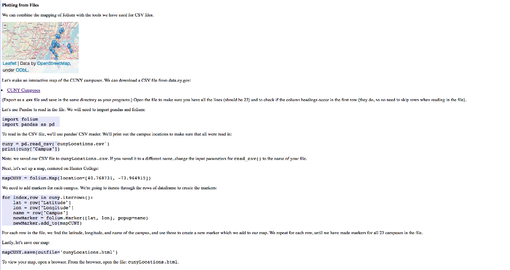
42. Due Date: 12 November Using folium (see Lab 9), write a program that asks the user for the name of a CSV file, name of the output file, and creates a map with markers for all the traffic collisions from the input file A sample run: Enter Csv file nanei collisione7hHunterBday.cev Enter output file: thMap.htmi which would produce the html file: Union City ORK TY Leatler l(c) OpenStreetMap contributors)CamoDB, CartoDB attributions (The demo above is for October 18, 2016 using the time the collision occurred (TIME) to label each marker and changed the underlying map with the option: tiles- Cartodb Positron" when creating the map.) This assignment uses collision data collected and made publicly by New Y 0 k City Op n Data. See Programming Problem 39 or details on this data set when creating datasets to test your pro ram, you will need to (to keep the files from being huge) and that there's a location entered. The former is explained above: to check the latter, add the additional filter condition of "LONGITUDE is not blank ter for both date Hint: For this data set, the names of the columns are "LATITUDE" and "LONGITUDE" (unlike the previous map problem, where the data was stored with 'Latitude" and "Longitude"). 42. Due Date: 12 November Using folium (see Lab 9), write a program that asks the user for the name of a CSV file, name of the output file, and creates a map with markers for all the traffic collisions from the input file A sample run: Enter Csv file nanei collisione7hHunterBday.cev Enter output file: thMap.htmi which would produce the html file: Union City ORK TY Leatler l(c) OpenStreetMap contributors)CamoDB, CartoDB attributions (The demo above is for October 18, 2016 using the time the collision occurred (TIME) to label each marker and changed the underlying map with the option: tiles- Cartodb Positron" when creating the map.) This assignment uses collision data collected and made publicly by New Y 0 k City Op n Data. See Programming Problem 39 or details on this data set when creating datasets to test your pro ram, you will need to (to keep the files from being huge) and that there's a location entered. The former is explained above: to check the latter, add the additional filter condition of "LONGITUDE is not blank ter for both date Hint: For this data set, the names of the columns are "LATITUDE" and "LONGITUDE" (unlike the previous map problem, where the data was stored with 'Latitude" and "Longitude")
Step by Step Solution
There are 3 Steps involved in it

Get step-by-step solutions from verified subject matter experts