

Question: Use flood routing analysis to determine the maximum water level for a flood control reservoir that has a watershed area of 50 ha. The runoff
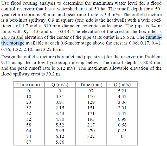
Use flood routing analysis to determine the maximum water level for a flood control reservoir that has a watershed area of 50 ha. The runoff depth for a 50- year return storm is 90 mm, and peak runoff rate is 5.4 m3/s. The outlet structure is a box-inlet spillway, 0.9 m square (one side is the headwall) with a weir coef- ficient of 1.7 and a 610-mm diameter concrete outlet pipe. The pipe is 34 m long, with K = 1.0 and n = 0.014. The elevation of the crest of the box inlet is 26.8 m and elevation of the center of the pipe at its outlet is 25.6 m. The cumula- tive storage available at each 0.6-meter stage above the crest is 0.06, 0.17, 0.41, 0.76, 1.32, 2.10, and 3.22 ha-m. Design the outlet structure (box inlet and pipe sizes) for the reservoir in Problem 9.14 using the inflow hydrograph giving below. The runoff depth is 80.8 mm and the peak runoff rate is 6.12 m3/s. The maximum allowable elevation of the flood spillway crest is 30.2 m Time (min) 0 10 23 32 42 52 58 64 74 87 Q (m/s) 0 0.31 0.91 2.15 3.43 4.70 5.52 5.95 6.12 5.86 Time (min) 97 110 129 151 171 193 217 270 322 Q (m3/s) 5.21 4.42 3.06 2.01 1.47 0.99 0.68 0.25 0 Use flood routing analysis to determine the maximum water level for a flood control reservoir that has a watershed area of 50 ha. The runoff depth for a 50- year return storm is 90 mm, and peak runoff rate is 5.4 m3/s. The outlet structure is a box-inlet spillway, 0.9 m square (one side is the headwall) with a weir coef- ficient of 1.7 and a 610-mm diameter concrete outlet pipe. The pipe is 34 m long, with K = 1.0 and n = 0.014. The elevation of the crest of the box inlet is 26.8 m and elevation of the center of the pipe at its outlet is 25.6 m. The cumula- tive storage available at each 0.6-meter stage above the crest is 0.06, 0.17, 0.41, 0.76, 1.32, 2.10, and 3.22 ha-m. Design the outlet structure (box inlet and pipe sizes) for the reservoir in Problem 9.14 using the inflow hydrograph giving below. The runoff depth is 80.8 mm and the peak runoff rate is 6.12 m3/s. The maximum allowable elevation of the flood spillway crest is 30.2 m Time (min) 0 10 23 32 42 52 58 64 74 87 Q (m/s) 0 0.31 0.91 2.15 3.43 4.70 5.52 5.95 6.12 5.86 Time (min) 97 110 129 151 171 193 217 270 322 Q (m3/s) 5.21 4.42 3.06 2.01 1.47 0.99 0.68 0.25 0
Step by Step Solution
There are 3 Steps involved in it

Get step-by-step solutions from verified subject matter experts