

Question: Which answer below represents the following diagram? interface> INavigable +GetLongitude() +GetLatitude() +GetAltitude() GPSWith Altimeter +GetLongitude() +GetLatitude( +GetAltimeter() -altimeter 1 Altimeter +GetAltitude() O a. The
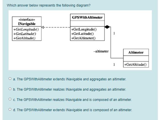
Which answer below represents the following diagram? interface> INavigable +GetLongitude() +GetLatitude() +GetAltitude() GPSWith Altimeter +GetLongitude() +GetLatitude( +GetAltimeter() -altimeter 1 Altimeter +GetAltitude() O a. The GPSWithAlitimeter extends INavigable and aggregates an altimeter. O b. The GPSWithAlitimeter realizes INavigable and aggregates an altimeter. O c. The GPSWith Alitimeter realizes INavigable and is composed of an altimeter. O d. The GPSWithAlitimeter extends INavigable and is composed of an altimeter.
Step by Step Solution
There are 3 Steps involved in it
The detailed answer for the above question is provided below The diagram shows a class named GPSWith... View full answer

Get step-by-step solutions from verified subject matter experts