

Answer the following questions regarding features on the geologic map shown in Figure G-25 (Appendix G). Use
Question:
Answer the following questions regarding features on the geologic map shown in Figure G-25 (Appendix G). Use the spaces provided on Fig. G-25. This exercise will require you to integrate information from previous chapters as well as this one.
1. For each fault (A, B, C, D, and E) determine the type of faulting that has occurred and bracket the age of faulting as precisely as possible.
2. Identify the following features indicated by circled, lower-case letters on the map.
(a) Type of contacts at localities a, b, c, and d.
(b) Specific geologic structure present at localities e, f, g, and h.
3. The strike and dip directions that are shown are correct; however, three of the dips are actually overturned. Correct these directly on the map by substituting the correct symbol for overturned beds.
4. Is the unit on the east side of the map labeled ‘‘Tm’’ older or younger than the other Miocene rocks on the map? Give a reason for your answer.
5. Determine the minimum amount of displacement on fault C.
6. Write a one-paragraph geologic history of the map area. Include all episodes of deposition, erosion, and plutonism. Also indicate when specific deformational styles (folding and faulting) occurred.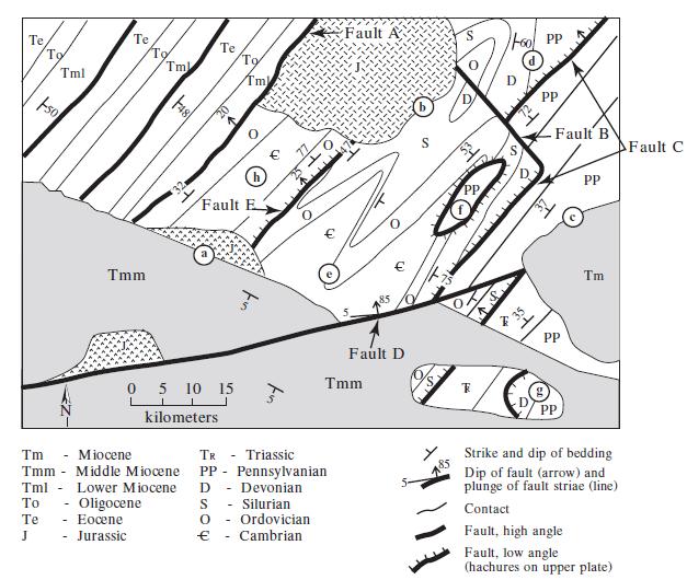
Step by Step Answer:


Structural Analysis And Synthesis A Laboratory Course In Structural Geology
ISBN: 9781405116527
3rd Edition
Authors: Stephen M. Rowland, Ernest M. Duebendorfer, Ilsa M. Schiefelbein
