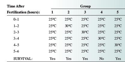
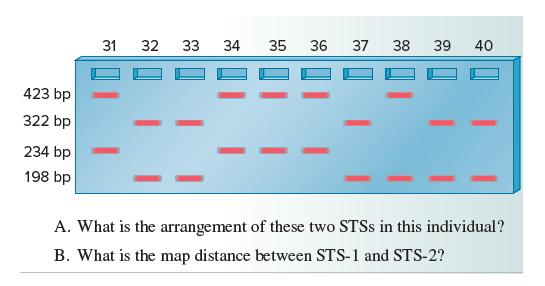
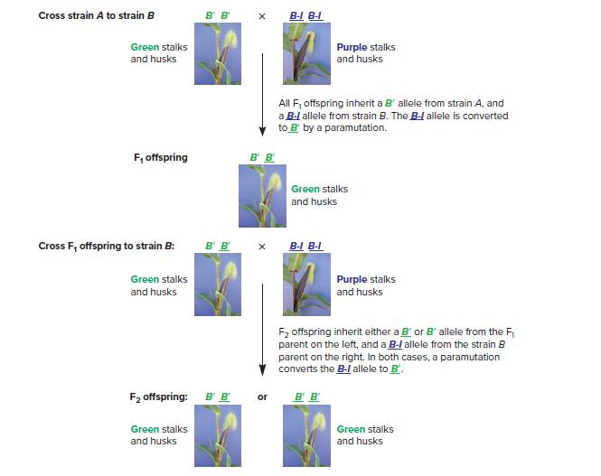
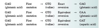
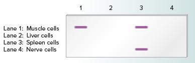
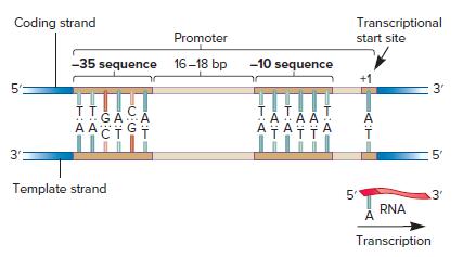
All Matches
Solution Library
Expert Answer
Textbooks
Search Textbook questions, tutors and Books
Oops, something went wrong!
Change your search query and then try again
Toggle navigation
FREE Trial
S
Books
FREE
Tutors
Study Help
Expert Questions
Accounting
General Management
Mathematics
Finance
Organizational Behaviour
Law
Physics
Operating System
Management Leadership
Sociology
Programming
Marketing
Database
Computer Network
Economics
Textbooks Solutions
Accounting
Managerial Accounting
Management Leadership
Cost Accounting
Statistics
Business Law
Corporate Finance
Finance
Economics
Auditing
Ask a Question
Search
Search
Sign In
Register
study help
sciences
structural analysis
Questions and Answers of
Structural Analysis
The beds below an angular unconformity have an attitude of 334°, 74°W, and those above 030°E, 54°NW. What was the attitude of the older beds while the younger beds were being deposited?
Draw structure contours on Fig. G-3. Use a 400-ft contour interval (including 0, 400, 800, 1200, etc.). Assume that, unlike the example in Fig. 2.8, this surface is not broken by faults, so your
Solve Problems 1.4 and 1.5 using the alignment diagram (Fig. 1.7).Problem 1.4Along a railroad cut, a bed has an apparent dip of 20° in a direction of N62°W. The bed strikes N67°E. Using
A fault has the following attitude: 080°, 48°S. Using orthographic projection, determine the apparent dip of this fault in a vertical cross section striking 295°.
Translate the azimuth convention into the quadrant convention, or vice versa.a) N12°Eb) 298°c) N86°Wd) N55°E e) 126° f) N37°Wg) 233°h) 270°i) 083°j) N3°W
Fault surfaces sometimes contain overprinted slip lineations (fault striae). Such slip lineations can be used to determine the orientation of slip on a fault, and, therefore, whether the motion on
Along a railroad cut, a bed has an apparent dip of 20° in a direction of N62°W. The bed strikes N67°E. Using orthographic projection, find the true dip.
Circle those attitudes that are impossible (i.e., a bed with the indicated strike cannot possibly dip in the direction indicated).a) 314°, 49°NWb) 086°, 43°W c) N15°W, 87°NWd) 345°,
On the geologic map in Fig. G-1 (Appendix G) draw the correct strike and dip symbol in each circle to indicate the attitude of Formation B and each dike. To verify your attitude symbols, Fig. G-2 can
A bed strikes 065° and dips 40° to the south. Two vertical cross sections need to be drawn through this bed, one oriented north–south and the other oriented east–west. By orthographic
A fault plane is intersected by two mine adits. In one adit the plunge and trend of the apparent dip is 20°, N10°W, and in the other it is 32°, N85°W. Use orthographic projection to determine the
Solve Problem 1.5 using trigonometry.Problem 1.5A fault has the following attitude: 080°, 48°S. Using orthographic projection, determine the apparent dip of this fault in a vertical cross section
Solve Problem 1.4 using trigonometry.Problem 1.4Along a railroad cut, a bed has an apparent dip of 20° in a direction of N62°W. The bed strikes N67°E. Using orthographic projection, find the true
The apparent dip of a fault plane is measured in two trenches. In one trench the apparent dip is 4° toward the southwest in a trench wall that has a bearing of 220°. In the second trench the
A mining company is planning to construct an underground coal mine within a thin coal seam that dips 2° due east. You are the mine engineer, and it is your task to make sure that the mine adits do
Points A, B, and C in Fig. G-4 are oil wells drilled on a level plain, and all of the wells tap the same oilbearing sandstone. The depth (not the elevation!) of the top of this sandstone in each well
The Paleogene (Paleocene through Oligocene) units of the Bree Creek Quadrangle were folded and then eroded nearly flat. Determine the approximate stratigraphic thickness of each of these Paleogene
Figure G-5 is a topographic map. Points A, B, and C are outcrop points of the upper surface of a planar coal seam. Point Z is an outcrop point of the base of the coal seam.1. Determine the attitude
Determine the approximate thickness of the Neogene units in the areas indicated. (Both the Helm’s Deep Sandstone and the Rohan Tuff have quite variable thicknesses. The Rohan Tuff was tilted and
On the Bree Creek Quadrangle map determine the exact strike and dip of the Miocene and Pliocene units and label the map accordingly with the appropriate symbol. List each attitude in the space below
Figure G-7 consists of three geologic maps, each of which has two topographic profiles below it. For each map there are at least two possible interpretations for the contact. Sketch two geologically
Draw topographic profiles and structure sections A–A’ and B–B’ on the Bree Creek Quadrangle map. Draw them as neatly and accurately as possible, and color each unit on the structure sections
Draw structure section A–A’ on Fig. G-9. Determine each apparent dip, using either the alignment diagram in Fig. 1.7 or trigonometry.Fig. 1.7Fig. G-9 True dip 70 60 40 30 20% 10 0¹ Apparent
Draw structure section A–A’ on Fig. G-8 (Appendix G).Fig. G-8 (Appendix G). A -NV 63 Fm. X 60+ Fm. B 65- Fm. X 62- Fm. Q 60- 50+ 55+ Fm. X -A'
On a piece of graph paper construct a stratigraphic column for the Cenozoic and Mesozoic units of the Bree Creek Quadrangle. Choose a scale that allows your column to fit comfortably on a single
An exploration oil well was drilled at the point shown on Fig. G-10 and the units encountered are shown on the structure section. The oil-bearing Eagle Bluff Limestone was encountered at a depth of
Figure G-12 (Appendix G) is a block model to be cut out and folded into a three-dimensional block. The surface with the north arrow represents a horizontal surface. You may want to color some of the
Using the data from the three drill holes shown below, determine the attitude of bedding. Hole no. | 23 Plunge and trend of hole 70°, N20°W 76⁰°, N80°E 68°, S30°W Angle between axis of
Figure G-58 contains three focal-mechanism solutions. Beneath each diagram write a description of the two possible interpretations for fault orientation and sense of motion (normal, reverse, oblique,
Figure G-13 is a sketch of the profile view of a set of folds exposed in the face of a cliff. First try to visualize the orientations of dip isogons on these folds. Then draw dip isogons at 108
Along a vertical railroad cut a bed has an apparent dip of 20°, 298°. The bed strikes 067°. What is the true dip?
In a mine, a fault has an apparent dip of 14°, N90°W in one adit and 25°, S11°E in another. What is the attitude of the fault plane?
A fault strikes due north and dips 70°E. A limestone bed with an attitude of 325°, 25°SW is cut by the fault. Hydrothermal alteration along the fault has resulted in an ore shoot at the
One limb of a fold has an attitude of 061°, 48°SE and other limb 028°, 55°NW. What is the orientation of the fold axis?
A coal bed with an attitude of N68°E, 40°S is exposed near the bottom of a hill. One adit is to be driven westward along the bottom of the bed from the east side of the hill, and a second adit is
You are mapping metamorphic rocks and you notice a lineation within the rocks. At five different outcrops you measure the pitch of the lineation on an exposed planar rock surface (not necessarily the
Two intersecting shear zones have the following attitudes: N80°E, 75°S and N60°E, 52°NW.1. What is the orientation of the line of intersection?2. What is the orientation of the plane
Iron-bearing minerals in volcanic rocks contain magnetic fields that were acquired when the magma flowed out onto the earth’s surface and cooled. These magnetic fields can be measured to determine
The dip direction of cross-beds in sandstone can be used to determine the direction that the current was flowing when the sand was deposited. A sandstone bed strikes 320° and dips 57°SW. Cross-beds
Figure G-15 contains five geologic maps, each of which contains folded strata. Fold a piece of paper to help you visualize each fold’s shape and orientation, then draw crestal and/or trough traces
In the northeastern fault block of the Bree Creek Quadrangle there is a hill that is capped by Helm’s Deep Sandstone overlying Rohan Tuff. In Problem 3.1 you determined the attitudes of these two
Figure G-14 contains photographs of four rock slabs. First, examine each photograph and try to visualize dip isogons on the folds. Write a description of the class or classes of folds you can
Figure G-16 shows the sides and top of a block model of folded layered rocks. The surface with the north arrow represents a horizontal surface. Cut out the pattern, and fold it into a block. Look at
1. On separate pieces of tracing paper construct a b-diagram and p-diagram for the folds in Figure G-17 (Appendix G). Determine the trend and plunge of the fold axis.2. Construct a profile view as
Three of the four fault blocks within the Bree Creek Quadrangle contain folded Paleogene rocks for which bedding attitudes are shown on the map. Complete the tasks listed below for each fault block.
Figure G-21 (Appendix G) contains an oblique view of a small map area showing several outcrops, some with parasitic folds. Each outcrop on the oblique view is represented on the map view (Fig. G-21b)
Figure G-23 contains a geologic map that shows both the bedding and cleavage attitudes. Using the cleavage– bedding relations discussed above, sketch a cross section of the map area showing the
Figure G-22 is a photograph of an outcrop in the Transantarctic Range of Antarctica. The view shows a cross section of beds of coarse conglomerate and finer-grained conglomerate. The arrow points to
Figure G-24 is a photograph of a slabbed rock that experienced two generations of folding. Compare this photograph with the patterns shown in Fig. 8.8; indicate which type of interference pattern is
In the southeastern fault block of the Bree Creek Quadrangle, Paleozoic rocks have experienced two episodes of folding, F1 and F2. The foliations shown on the Bree Creek map are axial planar. F1
Measure the slip in Problem 9.1 if slickenside lineations trend northwest and have a pitch of 60°.Problem 9.1Figure 9.7 shows the trace of a fault (330°, 50°SW) and a dike (040°, 35°SE) with 450
Figure 9.7 shows the trace of a fault (330°, 50°SW) and a dike (040°, 35°SE) with 450 m of strike separation. Assume that this is a normal fault. What is the amount of slip? Z→ O SE 0 100 450
Figure 9.9 is a geologicmap showing a fault.Onthe east side of the fault the beds all have an attitude of 335°, 40°E. West of the fault the rocks are poorly exposed, with only two outcrops, which
By stereographic projection, using the attitudes determined in Problem 3.1, determine the amount (in degrees) and direction of Neogene tilting on the fault blocks of the Bree Creek Quadrangle that
Answer the following questions regarding features on the geologic map shown in Figure G-25 (Appendix G). Use the spaces provided on Fig. G-25. This exercise will require you to integrate information
The table below lists measurements from 10 normal faults in a small area on the island of Crete (Angelier, 1979). Plot the data on an equal-area net and determine the orientation of the principal
Figure G-27 is a geologic map and structure section from the Inyo Range of eastern California. Using complete sentences, describe the history of principal stress orientations in this area. What can
Using the geologic map, your structure sections, and your work in this chapter, write a succinct, complete description of each fault in the Bree Creek Quadrangle. Use complete sentences, but avoid
Figure G-26 (Appendix G) shows three pairs of conjugate shear surfaces. Sketch the arrows representing the three principal stress directions on each pair of conjugate shear surfaces, as was done on
Figure 10.5 shows a map of a mine adit and a series of minor faults that occur in a homogeneous rock unit. Plot the fault planes on the equal-area net and determine the orientation of the stress
In one succinct paragraph, describe the history of the principal stress orientations in the Bree Creek Quadrangle. Be as specific as possible about the time intervals during which variously oriented
Figure G-28 is a generalized map of a portion of the southwestern United States showing the Basin-and- Range geologic province and bordering regions. The Basin-and-Range province derives its name
Asia contains a complex array of active fault types. As shown in Fig. G-30, for example, there is amajor system of thrust faults in the Himalaya (Himalayan Frontal Thrust), major left-lateral
The data tabulated below were collected within the Basin-and-Range province, from faults in southern Nevada, and from north of Hoover Dam in the Lake Mead area. Although local exceptions exist, the
On the e/time graph in Fig. G-32a (Appendix G) show the strain history of a standard linear solid that would correspond to the stress history in the s/time graph.Fig. G-32a eeeeeeeeeee tr: stress
a. A geologist studying thrust faults in a Proterozoic shear zone in southern Wyoming developed the hypothesis that all of the thrust faults formed during a regional
The rheologic model shown in Fig. 12.15 behaves differently at different strain rates. At high strain rates it behaves elastically (‘‘bounces’’). At moderate strain rates it behaves
Figure G-32b is a sketch of a folded rock layer. The limbs of the folds deformed without fracturing, while fracturing occurred in the hinge zones. In terms of rheologic models, explain why the same
In this problem you will quantitatively explore some rheologic models.1. Using a spring scale and meter stick, graph stress against strain for several rubber bands and springs. Are these perfect
Given the principal stresses of σ1 = 100 MPa (vertical) and σ3 = 20 MPa (horizontal), determine the normal and shear stresses on a fault plane that strikes parallel to σ2 and dips 32° (Plane 1
Plane 1 in Fig. G-33a has been plotted on the Mohr diagram in Fig. G-33b. Determine the normal and shear stresses on planes 2 through 5 and plot them on the Mohr diagram. (Recall that trigonometric
If σ1 is vertical and equal to 50 MPa, and σ3 is horizontal, east–west, and equal to 22 MPa, using a Mohr circle construction determine the normal and shear stresses on a fault striking
The results of four fracture experiments on samples of Rohan Tuff are recorded in the table below.1. Draw Mohr circles for each experiment, and draw the failure envelope.2. Determine the Coulomb
Suppose you are an engineering geologist designing a nuclear waste repository in the Rohan Tuff (see Problem 13.4). Figure 13.11 shows the general plan of the repository. It will be a large room, the
Figure G-34 shows a block of fine-grained limestone that was experimentally shortened by about 1% at room temperature. Four sets of fractures developed. Fractures of sets ‘‘a’’ and
Figure G-35b is a map showing the Johnson Valley Fault in southern California. This is a right-lateral strike-slip fault that lies a short distance to the north of the San Andreas Fault zone. On June
Figure G-36 (Appendix G) contains four photographs of slabs of a breccia from the Alps. The sample in photograph G-36a is undeformed; Fig. G-36b–d show slabs of this same breccia from nearby
Figure G-35a shows the failure envelope of a ‘‘tight’’ (low-permeability) sandstone, which is a petroleum reservoir rock. If σ1 = 72 MPa and σ3 = 42 MPa, determine the amount of pore
Figure 14.2 shows a diagrammatic brachiopod shell before deformation (Fig. 14.2a) and after deformation (Fig. 14.2b).1. Determine the extension e of the hinge line.2. Determine the angular shear C
Figure G-42a is a sketch of a hand specimen of oolite. The orientations of the principal strain axes have been determined in the field on the basis of lineations, cleavages, and the shapes of the
For each of the three photographs in Fig. G-37 do the following:Fig. G-371. Decide which field the strain ellipse lies in, and give your reasons. Refer to Fig. 14.8 for assistance.2. The circle next
Figure G-39 shows a dike and sill complex in which a competent rock, colored black, has intruded into a schist. The horizontal lines represent cleavage in the schist. Consider the cleavage planes to
FigureG-40is aphotographofanexposedbedding plane containing deformed portions of several trilobites.1. Determine the strain ellipse for this rock.2. Determine the 1 + e1: 1 + e2 ratio and the
Redraw the cross section in Fig. 15.4a to make it balanced. Assume that the footwall geometry is correct.Fig. 15.4a Total length, top of: layer 1 = 75 mm layer 2 = 89 mm difference = 14 mm a
For each lettered panel on the cross section in Fig. G- 43 (Appendix G), determine whether the panel in the hanging wall and the footwall directly below is a ramp or a flat. Write the term
Figure 14.15 shows some folds and associated structures produced by coaxial strain. Sketch a similar drawing of structures produced by noncoaxial strain. You may find it useful to use two or three
On the four drawings of deformed rocks in Fig. G-41, indicate the orientations of the principal strain axes. Below each drawing indicate the relative lengths of the axes (e.g., 1 + e1 > 1 + e2 = 1
Use the bed-length technique to restore the cross section in Fig. G-45 and evaluate whether or not it balances. That is, draw the stratigraphic template for the restored cross section below the
What was the principal deformation mechanism in the quartz in the photomicrograph shown in Fig. G- 49 (Appendix G)? What was the principal deformation mechanism in the feldspar? Provide evidence to
You have been hired by an oil company, and your first assignment is to take over a project from another employee. Figure G-48 contains a geologic map and topographic profile of an area that your
Figure G-47 contains a geologic map and topographic profile. Two wells have been drilled in the area, as indicated on the map. Well number 1 encountered a thrust decollement at 1500 m. Well number 2
Let us look more closely at the fault history within Field II of Fig. G-28. We will examine the detailed fault pattern of one small area at Hoover Dam on the Arizona–Nevada border, a highly
Balance the cross section that you evaluated in Problem 15.3. Use the footwall template provided in Fig. G-46. Assume that the footwall structure (i.e., position of ramps and flats) is correct. Use
What was the principal deformation mechanism operative in the rock shown in Fig. G-50? Being careful to use the correct terminology, list the lines of evidence that support your conclusion. Use
On Fig. G-51, label three examples of subgrains and three examples of new grains. Fig. G-51 Photomicrograph for use in Problem 16.3. Crossed polars. Scale bar is 1 mm.
Name the type of fault rock shown in Fig. G-52a, and explain what features you used to identify it. The protolith of this rock was a coarse-grained granite. The irregularly shaped, light-colored
Name the type of fault rock shown in Fig. G-52b, and explain what features you used to identify it. The protolith of this rock was a porphyritic granite. Type of fault rock: Diagnostic features: Fig.
1. Examine the photomicrograph in Fig. G-53. Describe the principal microstructures in the quartz and the feldspar, and interpret the deformation mechanisms that led to these microstructures.2. What
1. Figure G-54a shows a porphyroclast. What type is it?2. The shear zone that contains this porphyroclast strikes 050° and dips 70° to the southeast. Mineral lineations plunge 70° toward 140°
Figure G-55 is a tectonic map of a region that contains three major shear zones that were active at different times. For each shear zone a stereogram is provided that indicates the foliation and
Showing 1 - 100
of 688
1
2
3
4
5
6
7