

Question: A development project on a small upland watershed is shown in Figure 12. 23. The developed portion of the area is 0. 7 km 2
A development project on a small upland watershed is shown in Figure 12. 23. The developed portion of the area is 0. 7 km2 in which 21% is impervious area. The developed area is graded so that runoff is collected in grass-lined swales at the front of the lot and drained to a paved swale that flows along the side of the main road. Flow from the paved swales passes through a pipe culvert to the upper end of a stream channel. The upper portion of
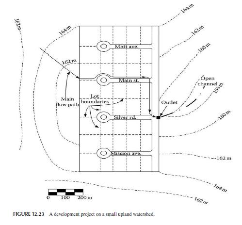
the watershed with a maximum height of 164 m is a forest with B-type soil (CN = 60) and has an area of 0. 3 km2. Estimate the peak runoff of this area if the design return period of the drainage system is 25 years. Use the IDF curve of Problem 3.
Data from problem 3 An 8 km2 watershed has a time of concentration of 1. 0 hour. Use HEC-HMS to determine the direct runoff for a storm (rainfall hyetograph given in Table 12. 6) using the SCS UH method.
162 m 164m 162 m Mott ave. Main Loti boundaries flow path 100 200 m Main st. Silver rd. Outlet 164 m 162m 160 m pen channel, 158 m 160 m Mission ave. --162 m FIGURE 12.23 A development project on a small upland watershed. 162 m 164m
Step by Step Solution
3.44 Rating (151 Votes )
There are 3 Steps involved in it

Get step-by-step solutions from verified subject matter experts