

Question: In Chicago, the road system is set up like a Cartesian plane, where streets are indicated by the number of blocks they are from Madison
In Chicago, the road system is set up like a Cartesian plane, where streets are indicated by the number of blocks they are from Madison Street and State Street. For example, Wrigley Field in Chicago is located at 1060 West Addison, which is 10 blocks west of State Street and 36 blocks north of Madison Street. Treat the intersection of Madison Street and State Street as the origin of a coordinate system, with east being the positive x-axis.
(a) Write the location of Wrigley Field using rectangular coordinates.
(b) Write the location of Wrigley Field using polar coordinates. Use the east direction for the polar axis. Express θ in degrees.
(c) U.S. Cellular Field, home of the White Sox, is located at 35th and Princeton, which is 3 blocks west of State Street and 35 blocks south of Madison. Write the location of U.S. Cellular Field using rectangular coordinates.
(d) Write the location of U.S. Cellular Field using polar coordinates. Use the east direction for the polar axis. Express θ in degrees.
The City of Chicago illinois.
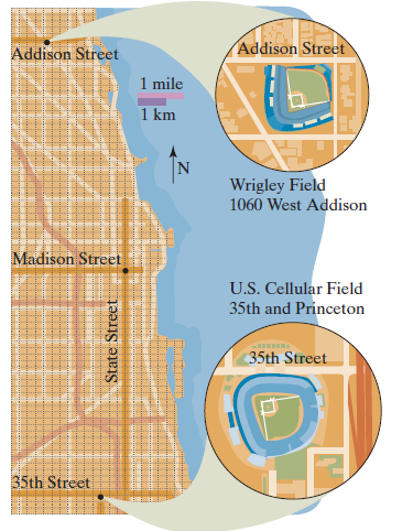
Addison Street Addison Street 1 mile 1 km Wrigley Field 1060 West Addison Madison Street U.S. Cellular Field 35th and Princeton 35th Street 35th Street State Street a
Step by Step Solution
3.36 Rating (174 Votes )
There are 3 Steps involved in it
a For this application west is a negative direction and north is positi... View full answer

Get step-by-step solutions from verified subject matter experts