

Question: Need a fix with this python3.xx arcgis coding you can generate your own geodatabase for testing print names and alias names of fields whose name
Need a fix with this python3.xx arcgis coding you can generate your own geodatabase for testing
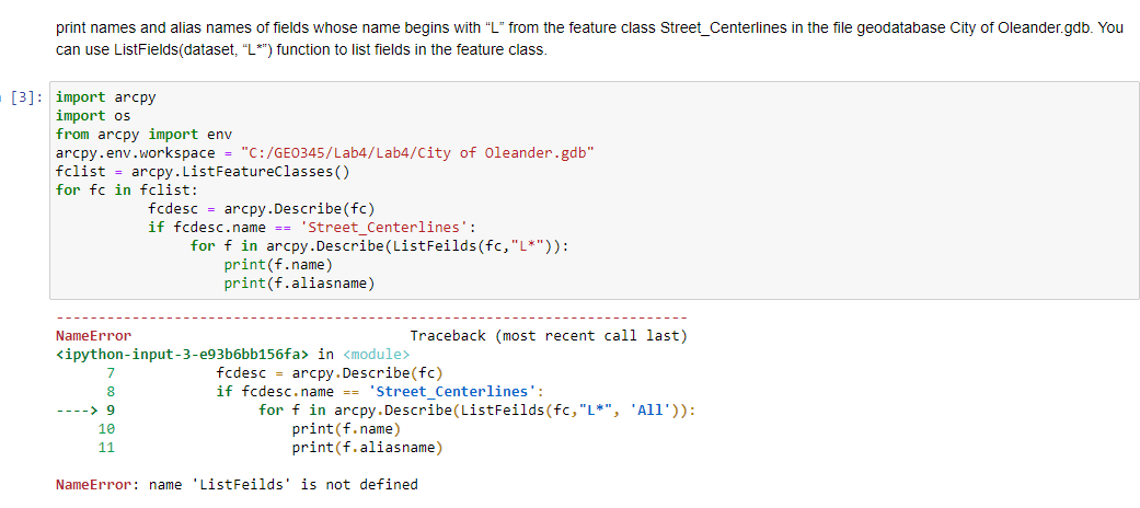
print names and alias names of fields whose name begins with "L" from the feature class Street_Centerlines in the file geodatabase City of Oleander.gdb. You can use ListFields(dataset, "L*") function to list fields in the feature class. [3]: import arcpy import os from arcpy import env arcpy.env.workspace = "C:/GEO345/Lab4/Lab4/City of Oleander.gdb" fclist = arcpy. ListFeatureclasses for fc in fclist: fcdesc arcpy. Describe (fc) if fcdesc.name == 'Street_Centerlines': for f in arcpy.Describe(ListFeilds(fc, "L*")): print(f.name) print(f.aliasname) NameError Traceback (most recent call last)
Step by Step Solution
There are 3 Steps involved in it

Get step-by-step solutions from verified subject matter experts