

Question: Figure G-47 contains a geologic map and topographic profile. Two wells have been drilled in the area, as indicated on the map. Well number 1
Figure G-47 contains a geologic map and topographic profile. Two wells have been drilled in the area, as indicated on the map. Well number 1 encountered a thrust decollement at 1500 m. Well number 2 encountered the following units: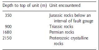
Regional mapping indicates that the thickness of Cretaceous rocks is 700 m.
Use the map, together with stratigraphic thicknesses from the well log and regional mapping, to construct a cross section on the topographic profile. Be sure to show the eroded layers above the level of the present exposure. Determine:
(1) The type of fold present, and
(2) The amount of shortening.
Figure G-47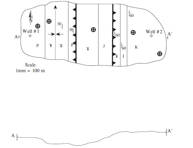
Depth to top of unit (m) Unit encountered 350 900 1680 2150 Jurassic rocks below an interval of fault gouge Triassic rocks Permian rocks Proterozoic crystalline rocks
Step by Step Solution
3.43 Rating (162 Votes )
There are 3 Steps involved in it
Fault dips 30 deg e Well 1 Sopu 8 e Well 2 Scale Imm100 m Fault dips 0 deg Soam E Fault Fault E ... View full answer

Get step-by-step solutions from verified subject matter experts