

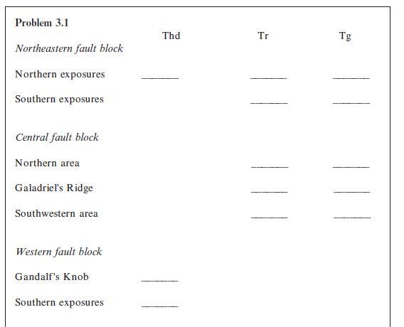
The Paleogene (Paleocene through Oligocene) units of the Bree Creek Quadrangle were folded and then eroded nearly
Question:
The Paleogene (Paleocene through Oligocene) units of the Bree Creek Quadrangle were folded and then eroded nearly flat. Determine the approximate stratigraphic thickness of each of these Paleogene units.
To do this, for each unit find a place that is not in the hinge zone of a fold, where the topography is nearly flat, where both the upper and lower contacts are exposed, and where the dip is fairly constant. The horizontal distance h must be measured perpendicular to the strike. A good place to measure the Bree Conglomerate, for example, is where Galadriel’s Creek crosses it in the southwestern corner of the map. In places where the dip is not completely consistent you may have to use an average dip. (Because of the large contour interval on this map and the absence of completely flat terrain, thickness determinations will be somewhat variable.)
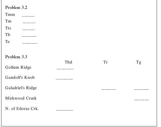
Tmm _____ (NE corner at 1600-ft contour)
Tm _____ (W of Galadriel’s Ridge at 36°W dip)
Tts _____ (NE corner at 2000- and 2400-ft contours)
Tb _____ (at Galadriel’s Creek)
Te _____
Step by Step Answer:


Structural Analysis And Synthesis A Laboratory Course In Structural Geology
ISBN: 9781405116527
3rd Edition
Authors: Stephen M. Rowland, Ernest M. Duebendorfer, Ilsa M. Schiefelbein
