

Question: and clean water - to the affected areas. The problem is daunting: many transport routes between the cities have been severely impacted by flooding, landslides,
and clean waterto the affected areas. The problem is daunting: many transport routes between the cities have been severely impacted by flooding, landslides, and other stormrelated damage. Time is of the essence, as supplies are limited and access to several cities is precarious.
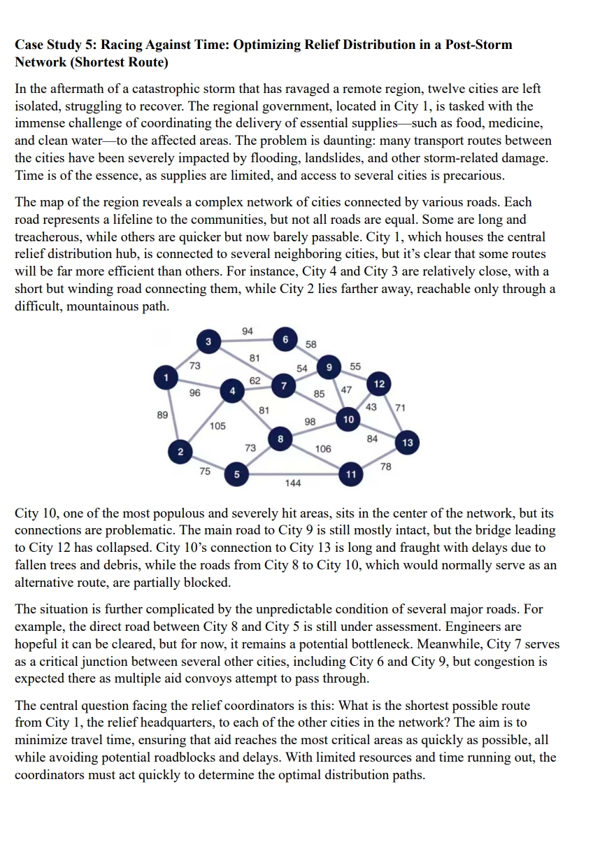
The map of the region reveals a complex network of cities connected by various roads. Each road represents a lifeline to the communities, but not all roads are equal. Some are long and treacherous, while others are quicker but now barely passable. City which houses the central relief distribution hub, is connected to several neighboring cities, but it's clear that some routes will be far more efficient than others. For instance, City and City are relatively close, with a short but winding road connecting them, while City lies farther away, reachable only through a difficult, mountainous path.
City one of the most populous and severely hit areas, sits in the center of the network, but its connections are problematic. The main road to City is still mostly intact, but the bridge leading to City has collapsed. City s connection to City is long and fraught with delays due to fallen trees and debris, while the roads from City to City which would normally serve as an alternative route, are partially blocked.
The situation is further complicated by the unpredictable condition of several major roads. For example, the direct road between City and City is still under assessment. Engineers are hopeful it can be cleared, but for now, it remains a potential bottleneck. Meanwhile, City serves as a critical junction between several other cities, including City and City but congestion is expected there as multiple aid convoys attempt to pass through.
The central question facing the relief coordinators is this: What is the shortest possible route from City the relief headquarters, to each of the other cities in the network? The aim is to minimize travel time, ensuring that aid reaches the most critical areas as quickly as possible, all while avoiding potential roadblocks and delays. With limited resources and time running out, the coordinators must act quickly to determine the optimal distribution paths.
Step by Step Solution
There are 3 Steps involved in it
1 Expert Approved Answer
Step: 1 Unlock

Question Has Been Solved by an Expert!
Get step-by-step solutions from verified subject matter experts
Step: 2 Unlock
Step: 3 Unlock