

Question: . The actual elevations (m) from a grid survey completed in a plot of land are given below. The grid spacing is 25m X
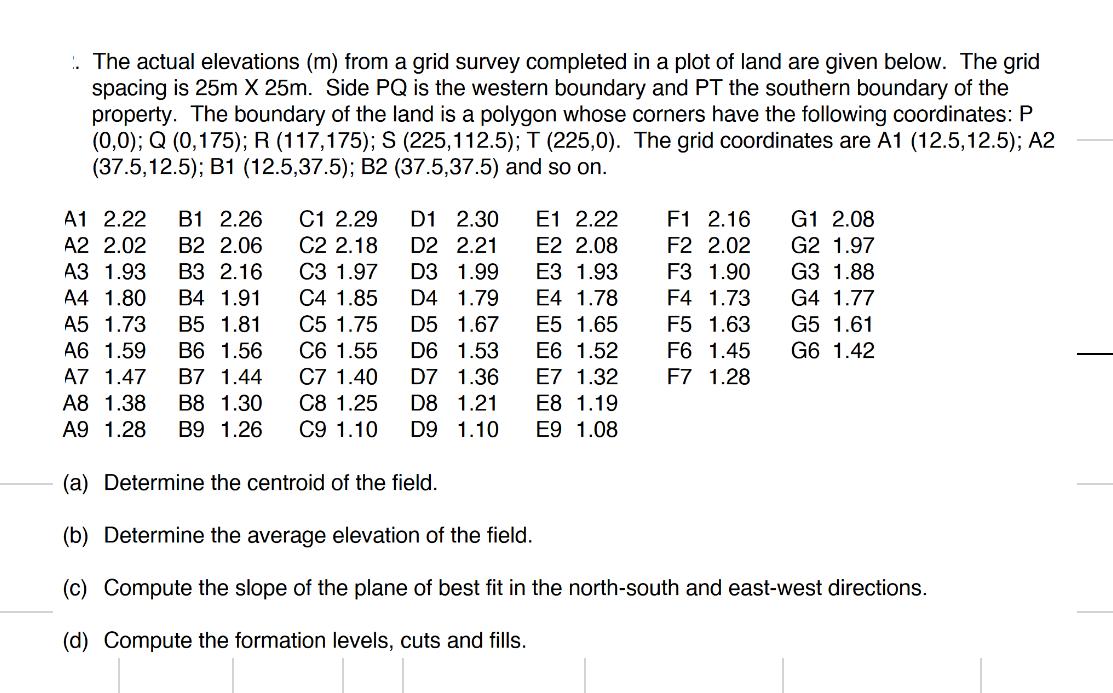
. The actual elevations (m) from a grid survey completed in a plot of land are given below. The grid spacing is 25m X 25m. Side PQ is the western boundary and PT the southern boundary of the property. The boundary of the land is a polygon whose corners have the following coordinates: P (0,0); Q (0,175); R (117,175); S (225,112.5); T (225,0). The grid coordinates are A1 (12.5,12.5); A2 (37.5,12.5); B1 (12.5,37.5); B2 (37.5,37.5) and so on. D1 2.30 D2 2.21 D3 1.99 C1 2.29 C2 2.18 C3 1.97 C4 1.85 C5 1.75 C6 1.55 C7 1.40 C8 1.25 D4 D5 1.79 1.67 1.53 D6 D7 1.36 D8 1.21 C9 1.10 D9 1.10 E1 2.22 E2 2.08 E3 1.93 E4 1.78 A1 2.22 B1 2.26 A2 2.02 B2 2.06 A3 1.93 B3 2.16 A4 1.80 B4 1.91 A5 1.73 B5 1.81 A6 1.59 B6 1.56 A7 1.47 B7 1.44 A8 1.38 B8 1.30 A9 1.28 B9 1.26 (a) Determine the centroid of the field. (b) Determine the average elevation of the field. (c) Compute the slope of the plane of best fit in the north-south and east-west directions. (d) Compute the formation levels, cuts and fills. F1 2.16 F2 2.02 F3 1.90 F4 1.73 F5 1.63 F6 1.45 F7 1.28 E5 1.65 E6 1.52 E7 1.32 E8 1.19 E9 1.08 G1 2.08 G2 1.97 G3 1.88 G4 1.77 G5 1.61 G6 1.42
Step by Step Solution
3.45 Rating (158 Votes )
There are 3 Steps involved in it

Get step-by-step solutions from verified subject matter experts